Sage loves these adobe homes with the cement floors - she was in heaven.
Run One - Dale Ball Trail system
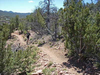
Monday AM, headed over to the northern end of the Dale Ball Trail system - a real Santa Fe gem. This network of twisty singletrack trails rolls in and out of wooded arroyos, up onto hilltops with pristine views (see above), and down into lush creek bottoms all in the middle of suburbia. Aside from some hilltop vistas overlooking million dollar adobe homes, most often the feeling out on trail was more remote. As we were getting our bearings and preparing for launch, an older gentlemen strolled into the trailhead at the finish of his morning run. Turns out, Mr. G is preparing for the Pikes Peak Ascent, his 19th running, at age 80. I hope I look that good at 80 - holy cow!
Kathleen rolls the northern end of Dale Ball trails.
It was sunny and moderately warm as we made our way through this exquisite labyrinth of trails. As would be the case each day (except Sunday when it snowed several times on the 5 hour drive...) sunny, cloudless skies would greet us each day - nice.
Kathleen is dropping into one of the arroyos in the photo above. It was amazing that within 500 - 600 feet net elevation change, there was so much variance in ecosystem - the desert has some cool stuff going on!
Climbing away - either up or down in the desert - no flat.
Topped out and ready for the final descent to the trailhead. It was a great day on trails and the Dale Ball has about 17 miles of singletrack trails, along with connections to the Atalaya trail, another popular Santa Fe route. We put in 10 miles on race-recovering legs and were pretty satisfied with our effort.
Shoes - K Asics 2150 Trail
S - LaSportiva Wildcat
Stats: 10 miles, 1850' elevation gain
Run Two - Jemez Mountain Trails
We have always been somewhat intrigued by the Jemez Mountain Trail races held in May each year in Los Alamos, a short jaunt to the northwest from Santa Fe. We figured we could swing over and check out the main loop used in the half marathon to get a taste for the trails. What we did not realize is that most of the race photos we had seen were from the 50k or 50M course, which venture out into the Valles Caldera National Preserve - it appears to have been spared from much of the fire damage. The HM course, unfortunately, is smack-dab in the middle of the massive burn area from the Cerro Grande fire of 2000. It would not take long to figure that part out. We headed into town and started from the Mitchell trailhead.
Once on the Mitchell trail, the climbing gets serious in a hurry. As you can see in the photos, the carnage from the forest fires is everywhere. This had to have been some beautiful forest previously - sad.
Lots of climbing through the downed Lincoln-Logs.
Bottom-center, you can see some of the switchbacks snaking the hillside. We were gaining altitude in gobs!
Some typical tread on the climb - looking up trail toward one of many switchbacks.
Kathleen climbing toward the top of Mitchell trail, not far from summit - whew!
Summit at last - 1540' ascent in 2.2 miles - ouch. That's about 13% average grade and serious climbing for our standards. This photo is at the junction with the Guaje Ridge Trail, which we would use to traverse the hillsides across several ravines. We would be dropping to the right on the photo. (For a reference point, the longer races head off the saddle to the left corner of the photo.)
Looking back across the Guaje Ridge Trail to Pajarito Ski area - you cannot even pick out the trail amongst all the downed trees! Lots of log hopping on the day - glad we were not on mountain bikes for this one...
We finally dropped onto the Upper Guaje Road trail, which was an abandoned two-track that was at times singletrack but mostly road width as seen above. The nice thing was that we finally got down into a mostly non-burned area - TREES and some color in the landscape - thank you!
Kathleen enjoying the Perimeter Trail.
We hooked up to the Perimeter Trail at the base of Upper Guaje - sweet singletrack cruise bordering the west side of Los Alamos. This trail rolled us all the way back over to the Mitchell trailhead. This run packs a big punch in a short distance, mostly due to that slog up the first stout climb. It is all premium singletrack aside from the Upper Guaje, however, be prepared for the sad sight of charred landscape if you go. (As a side note, I would not recommend this on a hot day - mid 60's sun felt awful warm in some places as you are seriously exposed here.) All in all, a good run of 10 miles, as we skipped the in town start/finish piece of the HM course. Los Alamos definitely warrants another visit - tons of trails and a very nice community.
***************************************
For a quick history/geography lesson to go with our trail story, here are a few photos from the aftermath of the Cerro Grande Fire - sordid details of this massive failure in oversight at Bandelier NM can be read here. 48,000 acres burned and 235 homes burned to the ground in Los Alamos.Circled area is the trailhead where we parked - first photo from Run Two.
Arizona Street with destroyed homesites - purple line is where Perimeter Trail now traverses.
Charred mountainside west of Los Alamos, most of which encompassed the top half of our run.
***************************************************
FYI - We would also suggest running the Frijoles Canyon Loop in Bandelier National Monument if you are in the Los Alamos area. It is a 13+ mile loop that we ran part of before we were real runners - spectacular trails that we were on and is on the To-Do list for the full loop. The Frijoles canyon had been flooding badly from late snow melt, so it was suggested to steer clear of the area. Next time...
Shoes - K Asics Gel Trabuco
S - LaSportiva Wildcat
Stats: 10 miles, 2300' elevation gainRun Three - Winsor Trail
We wanted a shorter, recovery type run on Wednesday, so we headed over to the Winsor Trail near the village of Tesuque, a bit west of town. This is a long trail that runs all the way up into the alpine areas around Santa Fe Ski Basin. We were hoping to just run a short section along Tesuque Creek to spin out a bit and stay cool along the water. It was forecast for upper 70's - not something we have had any chance to acclimate for in Colorado yet this spring! What we didn't realize was that the gentle climb along the creek was, um, not-as-gentle-as-hoped-for. This would be a great trail to explore when the higher, more alpine sections are dried out - snow runoff is apparently late from the cold spring weather.
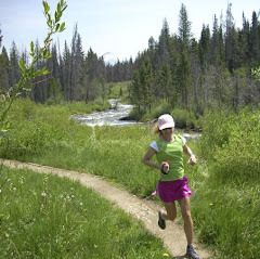
Tesuque Creek along the Winsor Trail.
We ended up running less than an hour but it was nice to run along with the sound of running water always on one side or the other. The legs were, however, in need of some rest so we kept it short.
Shoes - Both LaSportiva Wildcat
Stats: 4.5 miles, 975' elevation gain
Another Beautiful Desert Sunset.


