If you’re lucky enough to be in the mountains, you’re lucky enough!

Sunday, July 17, 2011

Another One Bagged: Bear Peak, Boulder, CO

Following a week of unstable weather with hot temperatures and evening storms, some quite violent, the weekend was calling for HOT and no rain - ugh!  Saturday morning we were out really early for a good tempo run on Santa Fe Trail - had to beat the heat, so we were off the trail by 9 am.  No time for pics, either :)

Sunday, we had an "appointment" in Boulder to meet up with Tim for a run, then have lunch to chat about crewing him during the Leadville 100.  The original plan was to run some nice trails in Flatirons Vista and Doudy Draw trail areas south of Boulder.  However, with the forecast high of 96 in Boulder, that plan got scrapped in favor of a less exposed, more forested route.  There is a trade-off:  The less exposed route is also quite steep....
 Starting into the Bear Canyon Trail


We started up the Shanahan Trail, climbing at a good rate but just seasoning the legs for the GOOD stuff to come.  Even with the 7:45ish start (yes, that meant rising at 5:15 on a weekend morning to drive to Boulder!!!), it was warming rapidly down on the southwest side of Boulder.  Fortunately, we were soon into the trees which provided a nice canopy for a large portion of the run.  From Shanahan, we caught the Mesa Trail and took that over to the start of the Bear Canyon Trail.  This is a very nice trail that ascends the canyon between Green and Bear peaks.  As seen above, it was a beautiful day.  We made our way up the Bear Canyon trail and then decided to see some new terrain and headed over toward Bear Peak.  The Bear Peak West Ridge trail starts to get a little more aggressive and it is apparent that it is traveled less frequently than the neighboring Green Mountain trails.  BTW, the trails are all shown on this map.
 Tim running the West Ridge trail - did you know this guy did Hardrock last week??
He even let us hold the buckle.....
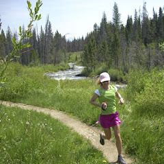
 Kathleen on a nice section of the West Ridge trail - she went rockstar today!!
 South Boulder Peak - the highest of the Boulder Skyline peaks
 Views are constant - The Continental Divide from one of the lower flanks of Bear Peak

After several runnable sections on the West Ridge trail, the ascent of Bear Peak becomes predominantly a struggle for survival good power hikeThe back side from which we would summit is all rock, so there is a lot of natural stair climbing.  Topping out at 8461', the summit of Bear provides stellar views:  Longs Peak to the northwest, the Continental Divide to the west, and Boulder and beyond to the east.  Spectacular - once you catch your breath.  At only a bit over 5 miles into our "run", we had already gained a whopping 3075' elevation - yowsa!
 Behind the tree and below the Flatirons, NCAR is perched on the open hilltop
 Longs Peak framed nicely by the trees

Time of day and rising temps caused another change of plans here.  The original route would have called for us to drop off Bear into Shadow Canyon and run it out to the bottom end of Mesa, then take Mesa back up to our trailhead.  This would have left a pretty good clip down low to run exposed to the sun.  So we were duped into followed Tim and dropped off the summit on the Fern Canyon Trail.  We have done a steep trail or two in our day.  But this thing is ridiculously steep.  We clipped off the first 1000' of descent in about three quarters of a mile - commence quad mashing session!  We followed Fern all the way down through the shaded canyon until we dumped out onto Shanahan again.  When we first came out of the trees in the last mile or so, the heat hit you in the face right now.  We were glad that the alternate route was chosen because that roll across Mesa would have been ROASTING!   The route ended up at 8 miles - a poor indicator of the work that it was!  A very scenic route nonetheless and did a nice job of prepping us for our next stop:
I was remiss in getting a group photo, so I had to dig deep in the HT photo
archives for some mug shots - a perfect collage with our favorite Boulder eatery!!!

No better way to refuel beat up legs than to head over to Beaujo's for some fine PIZZA and salad bar!  We sat around stuffing our faces and chatting up crew duties at the Leadville 100, now a quick 5 weeks away.  After his experience at Hardrock, this could be a great course for Tim to roll really well.  We're looking forward to it.  It was 91 when we left town, don't know if Boulder hit the upper 90's but it had a good start!  We had a great day and Tim delivered the goods on the trail tour as always!  Happy Trails!!

Shoes - K Columbia Ravenous
S - Montrail Masochist
T - Hoka BondiB

>>>>>>>>>>>>>>>>>>>>>
Just a quick update - if you recall, Kathleen had mentioned a while back that CU Boulder grad Michaela Cui was doing a charity ride from Alaska to San Francisco to raise awareness and funds for The Graves Disease Foundation.  A local television station in California did a news segment highlighting the ride - it can be seen here.  Michaela and Chris will be finishing the ride on Wednesday and celebrating in Crissy Park after crossing the Golden Gate Bridge - Congratulations after 3200 miles on the bike!!!

Wednesday, July 13, 2011

It's cool in them there hills

Last Sunday morning, we took off early to head into Mueller State Park near Divide, CO, for a trail run.  It was cloudy and very muggy at home but was supposed to warm up rapidly, so the half hour trip up the pass to run above 9000' elevation sounded like a solid plan.  We visited Mueller a month ago to try out some trails, and at that point, only half the park's trails were open due to elk calving.   So we had in mind to run the "other side" on Sunday, including a large loop we had done years ago on skis.  It was nice and cool, in the low 60's when arrived, but also quite humid.  Since we last blogged we have encountered a meteorological breakthrough - July Monsoon started and we have had at least some rain for six straight days (and it is raining now as I type).  With the rains has come humidity - an oddity for us and most likely short lived - which does not mix well with altitude and minimalist oxygen supply.  But the cool air sure was nice, so we sleeved up and hit the trail.
 Kathleen in big timber on Elk Meadow trail
 Morning clouds shadow the back side of Pikes Peak
 Who needs singletrack - go for Tripletrack!!!

We started out from the visitors center and ran over to catch the Elk Meadow trail, then ran it out to the Cheesman Ranch loop.  These trails alternate between shady forested paths to wide open rolling prairie grass.  As scenic as this park is, we saw almost no one the whole time we were out.  Aside from people really close to the parking area, we saw a mountain biker and two sets of hikers - that's it.  Talk about having the trails to yourselves.
 Old collapsed barn - a deer came out the side "door" as I approached 
and I nearly dropped the camera from the startling it gave me!
 Cheesman Ranch
 Almost to the top - Cheesman Ranch Loop

The trails on the northern half of the park, while more mellow in grade, follow the similar pattern to the trails we ran last month on the southern half.  The main road in the park is on the high spine, approximately 9800'.  All the loops start down, go through rolling areas, then ascend back to the spine.  We really like to finish on downhills - don't point fingers - YOU DO TOOThat does not happen here.  So after a long loop out on Cheesman, we finally made it to the top and decided to head over onto the Homestead loop and connect over to the Revenuer's Ridge trail we liked so much. 
 Starting out onto Homestead - dropping our hard earned elevation
 Meadow on Homestead trail - there are quite a few spots in Mueller
where the trail is grass instead of dirt
All finished - a nice tourist from Longmont, CO took our photo for us!
We enjoyed the trails we ran on the north part of Mueller and finished out our run just under 12 miles.  The elevation on the run ranged from 9200 to 9800 feet and the total climbing was around 2000' for the route.   It ended up being a fabulous day for running here as temps were in the low 70's when we finished - plenty warm when you are 2 miles closer to the sun!!!  Both of us had a good run and didn't really feel like pushing on any farther.  This area, as well as Rampart Reservoir nearby, give us good options for close proximity altitude training - gotta figure out that vexing little altitude issue I have going one of these days :)

Shoes - K Montrail Masochist
S - Pearl Izumi SyncroFuel XC

* * * * * * *
In other news, gotta throw out a huge congratulations to our friend Tim on his finish at the Hardrock 100 - you need to read his race report, then sit down and chew on it for a while - it is gritty, raw, a bit disturbing, but also a compelling look into arguably the hardest ultra out there.  Hats off to JT also for doing a heck of a job pacing Tim in from Telluride to the finish.

There is a video that has done laps around the net in ultra circles that also gives some insight into how this race tears you down to raw existence from John T Sharp's experience there in 2010.  You can see the "bigness" of this race a little bit in his video account.   I will warn you ahead of time, as his weariness builds, his language degrades noticeably - not in a vulgar way, more in a "I'm getting beat down by this race" way.  Just be warned and send your kids out for ice cream ;-):  http://www.youtube.com/watch?v=Hi93ivFcvy0

Saturday, July 9, 2011

Running in Mountain Bike Capital USA

The last few summers since we really got into trail running as a full time way of life, we have not spent much time in Winter Park.  In the heyday of our mountain biking 'past', we might sometimes be up there once or twice a month during the summer and fall, hitting the trails, enjoying the cool little mountain town, and generally 'Getting out of Dodge' for 2 or 3 days to regain some sanity.  The base area of the resort has changed a lot of late - not so much the mom-and-pop type area anymore, but more the commercialized ski resort.  With it came a summer shift too, as the mountain area is now a downhill / freeride only bike park - definitely not our gig  (used to call those bikers knuckledgraggers, but in deference to this guy, I must now find a more suitable name !!!).  We remember fondly (**old fart musing alert**) our days of "earning" the descent off that mountain by climbing the 2500 or 3000 feet elevation it required to reach that sweet singletrack on top.

But that's a rambling rant for another post, it was Independence Day weekend and we were hoping to beat the searing heat on the Front Range and escape the mass of humanity.  Score on both counts....Mountain Bike Capital USA (Winter park's summer tagline) - get ready for some trail running!!!
Givelo Trail - Fraser Rodeo Grounds trailhead

Saturday morning, we headed out to some awesome blue skies and low 60's temps - perfect running weather.  Parked over by the Rodeo Grounds in Fraser with the intent to do a big run - a large portion of the King of the Rockies Mountain Bike course.  The plan was for Kathleen to run part of the route, then swing up to Elk Creek to refill some of my supplies.  Might mention here - we have been bone-dry down on the Front Range, but there is water EVERYWHERE up here thanks to the very late Spring.  We had to drive through part of the Fraser River overflowing onto the road, which a car would not have made it through, just to get to the trailhead.
Northwest Passage with the Continental Divide in the distance

We cruised the  Givelo Trail over to Northwest Passage, enjoying the new life that is taking shape after the plundering of the mountain pine beetles.  Looks different every time we are back but the "different" is starting to grow on us.  We reached the CR50 dirt road and Kathleen decided to stay on the low route, bypassing the 3 mile run up the dirt road to the Tipperary trailhead.  She headed over to run the equally awesome Creekside - Flume loop on her own while I trekked up to the Tipperary Creek trail. 
  First crossing of Tipperary Creek


Made pretty good time up the road, albeit the exposure to the high altitude sun may have started to get after me.  Started in to Tipperary feeling a bit sluggish on the first steep ramp.  At the first creek crossing, I took off the shoes and socks and waded across about mid calf deep.  I don't run well in wet shoes, so this wasn't optional.  The first couple big switchbacks beat me down pretty good - 8 - 10% grade but should have run more of it than I did?  Maybe I went too hard last weekend...???

So here is a question that someone out there might have some insight into:  We have lived at a decent altitude (~ 6800 feet) for 20+ years.  However, the first day we are up high - like 9 or 10k and up, I struggle with the altitude (Kathleen doesn't seem to have this problem). It does not matter if it is bike or run, I always have.  Occasional light headed, some bouts of general malaise, and early onset fatigue, maybe even a bad bonk.  Generally day 2 is Wunderbar, so I don't get it.  Any ideas...???
Tipperary alternates between dense forest and big meadows like this
Heading down - dropping off Morse Pass on the steep Spruce Creek Trail

After a couple lengthier-than-desired walking spells, I navigated the second stream crossing with the aid of a fallen tree, and ran the much more tame incline out to Morse Pass - the top of Tipperary and the intersection with the Spruce Creek trail.  This route can be climbed either direction, the Tipperary side is 3.5 miles with about 1300' climb, most of which happens in the first 2.75 miles.  The Spruce Creek side is slightly over 2.5 miles with 1400' climb, so much steeper, not many switchbacks, lots of long straightaway views, and TONS of bigger, loose rocks.  So we, along with 99% of the other traffic, always go UP Tipperary.   Running down Spruce is a little tougher than biking it - you can't roll over the loose rocks like on a bike. 
Fraser River and Byers Peak - lots of snow still up there and may be there when snow flies again...
New intersection of Chainsaw and Zoom - once dense forest, now expansive views
Chainsaw / Zoom exit from the "forest" into Elk Creek
Looking south from Elk Creek road toward the ski area
Tired but satisfied - enjoying an awesome day

Shortly after making my way across Flume and the start of Chainsaw, I hit all fresh cut singletrack and a major re-route of Chainsaw.  The forest has been mostly clear cut from the beetles and it was exposed in the direct sunlight.  Then I cramped.  Just a short one.  Couple minutes later, again.  What's the deal with this??  The pounding from the 2.5 mile descent on Spruce, combined with the run over 10k feet, started to pool in the legs a bit on this climb, and I started to doubt that my run would continue on to the ski area.  I took 2 S-Caps and 2 gels in a 30 minute spell, but still couldn't shake the twinge in the legs.  I dropped out of Chainsaw onto Elk Creek road, where Kathleen was waiting to restock me and pulled the plug - 16 miles and nearly 3000' climbing was plenty for the day.  She could tell when she saw me crest the hill that I was done.  She had been able to enjoy a great day on the trails as well with 12 miles of sweet singletrack!  So we sat out in the meadow for a while, soaking in the fantastic day, then headed into Fraser for some Rocky Mountain Roastery java jolt!!!  Later that evening, Hernando's "recovery fuel" - the king of pizza in Winter Park ever since we started going up there in '91.  If you dig garlic, you must have your pie Simone style - mmmmmmmmmm!!!

Hello Mr Marmot
Classic steep mountain road

Sunday, we decided to run from the resort side, starting at the base of the ski mountain.  It's a little trickier now with most of the trails being downhill travel only, so we had to hop on the steep mountain road and head up.  One of our tricks from the bike is to grunt out the shortest route up, then enjoy long meandering trails back down.  So we headed up a little over a mile, caught a trail across the forest, and dropped in to what we previously knew as Upper Cherokee, now GreenWorld until you leave resort property.  Cruised down through the berms, which is weird for running, and then onto the long stretches of narrow, tree-lined singletrack that is Upper Cherokee.  Dropped across the water board road onto Lower Cherokee, which is much steeper and quite technical, and rolled that down to the Ice Hill trail.
Entrance to Ice Hill

Ice Hill is one of those little gut punchers - there are two short ramps with 20+% grades that really suck the wind out of you.  It was interesting because we passed through here twice on Sunday.  After some strong wind Sunday afternoon, when we ran through again on Monday, there were two fresh tree-falls across the trail - glad we missed out on that.  We continued out onto Little Vasquez, an old logging trail that is steep at times and very rocky.  It was great climbing along listening to Vasquez Creek and the many raging tributaries through the woods here.  We also passed under one of the Denver Water Board viaducts that carry water through the Moffat Water Tunnel right next to the train tunnel.
Vasquez Creek is roaring - this weekend's MTB race will be re-routed 
around the traditional stream crossing unfortunately

After running the service road over to the top of Blue Sky trail, we dropped in there for a nice cruise through the forest with the refreshing sounds of the creek roaring far below us at the top, then crossing over it on the foot bridge (seen above)  where the water is practically lapping your feet from underneath the bridge it is so high!  Out the bottom of Blue Sky and across the road put us back on Ice Hill, which we took over to Serenity Trail - as the name implies this is a fantastic, peaceful forest run with a nice bed of soft pine needles making it easy on the feet.
Bridging a marshy area on Serenity Trail
Moffat Tunnel - trains are constantly passing by Winter Park Resort, turning into the mountain
and 6.2 miles through the Continental Divide, and down onto the Front Range

Finished out a great run at the ski area village with 11 miles and around 2000' climbing for the day.  We tooled around a bit and headed back to the room to get cleaned up and drive out to Lake Granby and Grand Lake - the headwaters of the Colorado River.  We were quite curious about the water level and were happy to see it at the highest point we have observed in over ten years since our mountain drought hit hard in the late 90's.  Needless to say, it was a zoo over there and we did not linger or bother trying to walk the boardwalk in Grand Lake - half of Colorado's population looked to be there on Sunday!!!!

The Coca Cola bear gets a hug!
Ice Hill Trail on another awesome day

Boy, did we ever hit the jackpot on weather for this trip.   Monday the 4th it was once again bluebird skies when we headed out for a run.  We were a bit tired but decided to roll out from the base, across Serenity trail to Ice Hill, then up Twin Bridges and back the way we came.  It is hard to leave when the trails are so great, the weather is nice, and the summers are so short up here - have to maximize that time!!!
Running Twin Bridges trail
Vasquez Creek along Twin Bridges

The first of the "twin" bridges was our closest connection to the roaring creek.  The planks were soaking wet and the rapids were jumping 3 to 4 feet up from the current.  So we had to pass on the refreshing mountain stream leg soaking - maybe another day :)
Group mug on Twin Bridges

We rolled back the way we came and cruised in to the ski village on tired but happy legs.  7 Miles to cap off a great weekend getaway.  Got some coffee and snacks, and sat out at the base people watching for about an hour before starting the trek back home from the mountains!  Sorry it took so long to get this puppy loaded but it has been a crazy week.  Happy Trails!!!
Related Posts with Thumbnails