Last Sunday we took a drive up to the northwest part of the state. We like to stay clear of I-70, so we went through South Park and caught Highway 9 over Hoosier Pass - pictured above, then up through to Rabbit Ears Pass and over to Steamboat Springs. August is sometimes a spotty month for travel across these areas as the dry summers can occasionally leave a lot of brown, drab landscape. However, with the REALLY long/cold spring in the mountains, everywhere we drove it was green and lush. And yes, folks in the mountains are actually talking about summer starting, just in time for about 6 weeks of it until snow starts up high - ouch, is that ever a short season! Did a double take on the sign marking the distances off the pass - see below:

Couldn't help noticing someone had been on Hoosier Pass recently.... We had to stop and pay homage!
(Any coincidence that Beth placed her sticker so close to High Country Healing???)
After the 4.5 hour drive over to Steamboat, we drug out the road bikes and went for a nice, mellow 18 mile spin around town to flush out the legs a bit (we had done an 8 mile tempo run the day before). This is a great place to bring the bikes as there are countless miles of quiet country roads to ride without fear of being run off the road or ending up in crazy traffic. We even sat out at Starbucks enjoying some great weather and kicking the feet up while enjoying some high octane beverages!!! We also spent some time pouring over the map plotting out our trail excursions for the next several days. Let's get rolling!

The Rabbit Ears - unique volcanic plugs atop Rabbit Ears Peak
Monday found us back over on the east side of Rabbit Ears Pass at the Dumont Lake trailhead for the Wyoming Trail, part of the Continental Divide Trail that crosses from Rabbit Ears to Buffalo Pass. This is some wide open country as the total trip across is over 20 miles by road from east to west and it is about 18 miles by trail from Rabbit Ears to Buffalo.

Dumont Lake - alpine lake #1 for the day

Kathleen on the start of the Wyoming Trail
The first 1.5 miles of the trail winds gently along a diversion ditch that the forest service uses to spread out the watershed. The trail skirts a huge alpine meadow above Dumont Lake that is bursting with wildflower activity. The trail dips through a stream near a diversion point and then sharply climbs into the first section of forest.

Been a while since we had snow on the trail
The dense forest, along with elevation that is mostly in the 10k + range, harbors snow for long periods of time and it is holding on to quite a bit this year. This was the start of many miles of snow, mud, and standing water on the trails - summer is almost here!

Indian Paintbrush bloom along the Wyoming Trail, just before Base Camp

One of MANY creek crossings on the day - Fishhook Creek after the descent from Base Camp
After about 4 miles on the trail, there is a connection over to the USFS Base Camp trailhead. From here, the Wyoming Trail continues on, shown at times on maps as Trail 1101, Base Camp Trail, CDT - all the same trail. There is a sharp descent in to the Fishhook Creek drainage, quickly followed by another climb up to Fishhook Lake - #2 alpine lake of the day. Base Camp is a popular spot for hunters who pack in on horseback in the fall - wear blaze orange if you run here in the fall!

Fishhook Lake - stunning. Why would anyone want to live here....???

HT at Fishhook Lake

Next up - Lost Lake - we found it!

Finally to #4 - Lake Elmo
We had some great stretches of trail out past Lost Lake to Lake Elmo. A lot of the trail passes through meadows that are seeping marsh ground and there was lots of standing water on the trail. We got pretty used to the shlish-shlosh feeling of soaked feet as we ran 90% of the day that way. Lake Elmo was the elusive lake for us as we have seen the others before either from the Rabbit Ears side on foot, or from the Buffalo Pass side on mountain bike. When you look west from the trail at this point, you are looking over the back side of Mt Werner, home to Steamboat Springs' ski area.

Starting back from the far side of Lake Elmo - just around the bend, the trail is under water

Leap of Faith!
Given the fact that back in March Kathleen could at times barely lift her arms shoulder high, and had to carefully step up or down for trail obstacles because she had lost all her strength, seeing her regain enough strength to jump across the creek was one of the moments that made the trip for me. While she is not by any means back to her old kick, this was a moment that gave me a spark of hope that we have her headed on the right track!

Typical trail surface for most parts of the CDT - lots of footwork, no daydreaming

Heading back down from Base Camp

Racing the rain clouds back to the trailhead
The clouds had pushed in on us pretty heavy from the start. We had several periods where the sun teased us for a while, but moreso we were watching the skies, not wanting to be caught out in the expanses of this pass in severe weather. It is not like the rain would have hurt so much - we were wet from the knees down the majority of the run. The lightning is what you have to fear up here!!!

Coming out of the forest with Dumont Lake off in the distance

Dropping out into the huge meadow and the connection along the diversion ditch

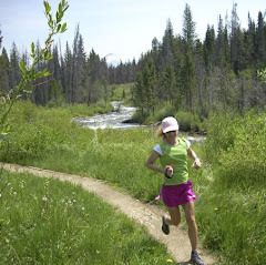
Kathleen runs in the wildflowers

Back to the start - Rabbit Ears monument and the end of the trail
This photo was a bit deceptive - the skies to the northeast were still showing blue, yet behind Kathleen as she took the photo were huge black storm clouds. We finished out with 15 miles in pretty big country. Although the trail conditions weren't perfectly stellar due to the standing water on much of the trail and the profuse number of downed trees that broke up the running rhythm at times, it was a great day to be out. And what a better way to end a run like this - we had left over pizza from BeauJo's waiting in the car - nice! Stay tuned for more from the trip and here are some parting wildflower shots on the way out from the trailhead!

Could you run here?

Red "Carpet" treatment

Flowers everywhere
Other than at the parking area at the trailhead, we did not see another person along the entire route. Peace, quiet, and solitude......
BTW, minutes into our drive back, the rain commenced - Happy Trails!