Saturday
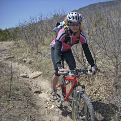
It is that inevitable time of year where a certain, all-too-familiar panic sets in: We want to cram as much trail activity into our late summer/early fall as there is no guarantee when it hits the fan (aka, the snow starts to fly!!!) The season is especially short in Colorado's high country and we had yet to visit Winter Park this year, so we loaded up Sage and took off after work Friday night for WP. We hit the weather jackpot for the weekend - clear blue sky and upper 70's in the mountains - wow! Saturday, we dropped Sage at Mountain Dawg daycare in Fraser since she no longer likes to run with us and took off on some of the popular mountain biking trails for a nice run. Kathleen is enjoying the Twin Bridges trail in the morning shade. With starting elevation at just shy of 9000' we would be in for a warm day - high 70's at altitude gets to you quickly (along with the lack of oxygen). We ran a lot of our favorite MTB trails on the valley side last summer on vacation, so we hit some of the trails closer to the ski area today.
 We climbed up D4 toward the WTB trail, one of my personal favorites because of the naming significance: It is named for Wade, Todd, and Bill - the guys who developed the trail. It just so happens that Wade Wilderman is also the KING of mountain coffee, founder of the Rocky Mountain Roastery, which is home to some of my favorite beans. A cup of Singletrack, brewed really strong, would be good for this trail because it is rocks, roots, and quite technical, requiring some hyperactive footwork!!!
 Kathleen poses with the marker for WTB. One of the great things about WP is that the trails are well marked and generally kept in good shape. (The ski mountain is another story, now that the knuckle draggers ~ downhillers ~ have taken over - all rutted and brake scarred trails from long travel MTB folk who have never climbed to earn their descent, which is pitiful!) I digress. Back to sweet trails.
  Generally we don't often stop on technical sections for photos because: A - It takes a lot of concentration and camera is second thought. and B - It would be a drag to fall and smash yourself up while trying to get pics. However, we wanted to at least show a bit of the terrain - this is the "tame" section at the top. WTB is a quad masher descent, all techy stuff, into a drainage followed by a steep climb right back out the other side. It is much easier to ride the descent and much easier to run the ascent, if that makes sense. But overall, we agreed that the run was more fun :-) We made a large loop and made our way back around to the Vasquez Creek drainage and down the fabulous Blue Sky Trail.
 It was here that I made a disturbing discovery - and prematurely finished my running for the weekend: My new Saucony Progrid Xodus have proven to be my "achilles" ~ I rolled my left ankle again on the descent of Blue Sky. Third time, same shoe, done running. Many miles in Montrail, Brooks, and Asics with no ankle issues - so retirement is imminent for this shoe. C'est La Vie!
We ended up with 12 miles and ~2500' vertical. Nice day out in the high country and awesome weather. No need to mention shoes . . . .
Sunday
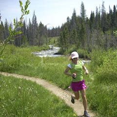
Sunday morning Kathleen got ready to run and I got Sage ready to go for a hike, or as she sees it, a Deluxe Walk. We dropped the mother off at the Northwest Passage trailhead to start her run. This used to be a heavily forested trail that was always cool, even with overhead sun. We have a problem in Colorado, though, in the form of the Mountain Pine Beetle. (Read about it here or there if you want some insight.) The bottom line is this, by the early stages of next decade, we will have lost about 80% of our Lodgepole and Ponderosa forest to this bug and our forests will be undergoing a huge transformation.
 Here is the result - once a shady, tree-lined trail that is now eerily open. Kathleen meets us at the far end of Northwest Passage before heading onto the Creekside trail. We think eventually it will look nice as the smaller trees and lower growth rises - it just isn't that time yet.
 While Kathleen ran the loop on Creekside and Flume, I took Sage over to the Fraser River for a little dip to cool off. I tried to convince her the black fur coat was a bad choice, but did she listen?!?! She then found a spot in the shade, right in the middle of the trail, and plopped down to wait for the mother.
 A refreshing piece of the Fraser River.
 Sage - all smiles and loving the trail!
 . . . And finally, emerging from the woods, Kathleen navigates the roots on the descent to the creek from the Chainsaw Trail.
 Byers Peak stands tall on the horizon - four years ago, you would never have seen far enough to know the mountain was there from this spot. The residents in this area are to be commended for their proactive approach to clearing the beetle kill. There is a mill in the area that is manufacturing lumber from beetle-kill pines for use in "green" construction. There is a limited time in which the wood is useful, so they are trying to use it so it is not wasted.
 After hiking back a ways Sage finally caught sight of the mother on the trail and took off running with her - nice grin, eh? Kathleen logged a nice 8.5 miler before we headed out for home. It was a nice little getaway in the mountains and we enjoyed our time!
*********************************************
^^^^^^^^^^^^^^^^^^^^^^^^^^^^^^^
^^^^^^^^^^^^^^^^^^^^^^^^^^^^^^^
Rocky Mountain StairMaster
 Looking up the Incline to the false summit.
Deb and I headed over to the Manitou Incline Monday morning for our "stairmaster" workout. Typically, Monday is a designated "ride" day but I wasn't in the mood for a ride - a good climb was calling my name! For those who are not familiar with The Incline, it is an abandoned cog railbed that climbs 2000 vertical feet in one mile. It has just under 3000 railroad tie "steps". The average grade is 40%, with the steepest middle third hitting 68%. We don't run it. In fact, I have seen very few people run up it over the years (maybe 3?). For us mere mortals, it is a steady march to the top. The fastest I have ever done it was 32 minutes, which is quite respectable. Today I was not as quick, but still decent at 34 minutes. Wow, a 34 minute mile!!!! Yahooooooo!!!! And that will certainly get your heart rate up!!!
 I put a little time on Deb and was able to snap this photo of her cresting the top. I think she is smiling because it's all downhill from here (and because I told her to smile!)! You can get a sense of the steepness looking down behind her.
 Snapped our customary group photo and then connected over to Barr Trail for the run to the bottom. I had wanted to do a little exploring on a different Barr Trail connector from the top of the Incline that would have dropped us out a little higher on Barr consequently resulting in a longer run down (good!). But the weather was looking a bit threatening and mountain lightening scares the crud out of me so we headed down instead of looking for the unknown. We will explore when the weather is sunny and smiling down on us. It was a great way to spend a morning - with a good friend and a good workout!