If you’re lucky enough to be in the mountains, you’re lucky enough!

Monday, June 27, 2011

Beat the Heat at Rampart Reservoir

 Early morning sun on Rampart Reservoir

Saturday was a photo-less long run day so you will have to visualize for yourself...  Kathleen had to work, so we ran to the top of Mesa Road and she returned home to round out a 9.5 mile morning jaunt and tend to her duties.  I looped through the Garden of the Gods, down Ridge Rd and made a lap around Red Rock Canyon before returning home the same way.  20 miles and glad to be done before the big heat.

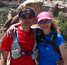
Sunday's forecast was for 90's, so we headed up Ute Pass to check on the city's water supply at Rampart Reservoir.  We had to get an early start or else miss out on parking spots at our favorite trailhead.  At 9300' elevation to start, the air is generally at least 10 degrees cooler than it would be at the house at 6800'.  It was an absolutely perfect morning with clear blue skies and mild temperatures - time to get rolling.
 Quiet bay
 Massive granite boulders are numerous along the trail

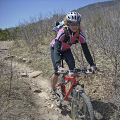
We like to start at the Rainbow Gulch trailhead and run down to the reservoir.  It means you have to finish with a climb, but it also makes the run a little longer :)  Early on in the run, we saw mostly fisherman down on the shore in various places, a couple runners, a mountain biker, and these folks:
 Kayakers enjoying the quiet morning
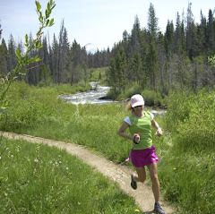
 Running some nice forest trails
 Views like this distract along the entire route

As we have said before, this is one of those "trick" runs.  Aside from the raw elevation, this trail has no extended alpine climbs nor does it have abundant technical footing.  However, the constant jaw-dropping views and incessant ups and downs that come with running the the shoreline of a mountain reservoir place a drag on your concentration, and eventually, your energy reserves.  There is a constant struggle to push an even pace - so this is a good mental training run, although the reservoir usually wins the struggle....
 Kathleen cruises the scenic trails
 Once again - views on the right, wait...watch your step...
 Looking out from the dam - the sharp point left of center is Blodgett Peak

Standing on the dam, looking out across the ridge you can see a wee bit of the sprawl that is Colorado Springs.  Here is the odd thing:  it is about a 28 mile drive to get to the trailhead from our houseBlodgett Peak is only about a 3-ish mile hike from our front door.  From Blodgett to the reservoir, as the crow flies, is maybe 3 to 3.5 miles.  So you start wondering, if there was a good route, why not just bust over the hill from home, trudge up to the reservoir, run a lap, then run home???  Hmmm, maybe some time pouring over the Ormes Pikes Peak Atlas map is in order...
 Back around to the inlet - plenty of snowmelt pouring in

After crossing the dam, the west side of the reservoir goes by in a flash as the 2.5 miles or so on that side seem so short compared to the length of the eastern side with the large inlets.  Running through the forest, more and more light peers through, the sound of rushing water tickles the ears, and then you pop out of the trees along the inlet, ready for the climb out to the trailhead.
Stop for a pose

From the footbridge, it is about a mile and a half climb out, starting on sweet singletrack following the inlet.  At the end of the trail, it is back out onto a wider trail (more like a road) that is quite exposed - it was here we noticed just how warm it was becoming, and we were glad to be finishing, not starting as so many were.   The route ends up at 14.25 miles with just under 2400' climb.  It was a bit of a stretch for Kathleen, but she made it.  It was a great run - yet another that is so close to home!  We stopped in Woodland Park for some Starbucks refueling, then stopped on the westside of town to hit Rudy's BBQ for some awesome smoked turkey and green chili stew to repair some tired legs!!!  We were glad to have been up high - we hit 96 degrees in town, only 2 degrees shy of a record high!   Happy Trails!
Satellite view

Shoes - K Pearl Izumi SyncroFuel XC
S - Montrail Masochist

Wednesday, June 22, 2011

Sunday Fun Day in the Garden

 Postcard Perfect Day at the Garden of the Gods

So how do you follow up the day after doing the infamous Incline???  Gingerly, for one.  Kathleen and her sick friends will paint this as the ultimate joy fest (don't fall for their ploy!) that you can't live without doing on a regular basis.  If you want the truth, it hurts...for days...  Sunday we decided to take our mashed quads over to the Garden of the Gods for some good trail running.  We woke to a gray blanket of cloudcover and upper 40's temps - what?  The Weather Liars Channel said it was to stay all day, so we were not in much of any hurry to get moving.   Then the clouds started to peel open and we knew we better get rolling.  Sure enough, by the time we got to the Garden - BAM - full sun and warming up rapidly.  Nothing like sun, blue skies, and this scenery to get you rolling on the trails!!!
 On the way up, stopped by my favorite withered tree

I have been getting some great mileage out of the trails we picked up while doing part of the Ponderous Posterior back in January especially during the long runs.  This would be Kathleen's second pass on some of them so it was pretty "new" for her.  We departed the Palmer trail out of the Garden and headed up onto the ridge into Pike National Forest land.
 Kathleen on the way UP!
 The desert is alive - finally

The climb out to gain the ridge is quite stout and the humidity left from the early clouds was pouring off of us in sheets.  The ridge we were climbing is also exposed from sunrise and sheltered from the breeze, so it was baking pretty good at this point.  After gaining the ridge, we ran the contour north to the water tower above Queen's Canyon and dropped out onto Rampart Range Road. 
 Cruising down RRR - enjoying the long descent!

Rampart provides a nice long descent after the harsh climb, and is also noticeably cooler than the front side was.  After approximately 3 miles, we popped back out into the Garden and ran around near the Trading Post.  We intended to run a newer cut of trail up and over to the Scotsman, however, the initial climb had a really long horse train headed up.  The stable folks from the Garden aren't too keen on letting you pass them, and riding behind a dozen or so 1000-lb walking crap factories on a hot day is a no no :)  So we cut over to the Siamese Twins trail and looped around to cut back onto the trails to the south before the horse train got there.
 Stunning landscape to run in - what is keeping you from running here...?
Temporarily Green - the valley vista

We made our way around the outer loop and headed back up to the visitor's center trailhead.  Kathleen called it a day here after a great 10 mile trail run - feeling good, too, I might add!  I topped off the water in my pack and decided against my laziness my better judgment  to run back through the park, and up Flying W before heading home for the day.  The legs were fairly toasty after 16 miles and it was time to be done.  Another great day running in some hard to beat locations.  I know, we have it rough.  But someone has to do it ....  Happy Trails!!!

Shoes - K Asics 2150 Trail
S - Saucony Progrid Peregrine

Saturday, June 18, 2011

If you are So Inclined!

Our initial plan for the weekend was to head to the mountains.  We nixed that idea when the weather forecast for the area we had planned looked sketchy.  We'd rather save the drive time and money for a pristine weather weekend.  We were twiddling our thumbs with no definite weekend running or riding plans when we received an email from our friend Jill late last night wondering whether we would like to join them for a climb up the Incline this morning.  I responded a very enthusiastic YES (I LOVE the Incline - it is a great, quick, intense workout that is a nice change of pace.  Steve isn't as enthusiastic about the Incline as I am - he usually goes along mostly to humor me, I think.  LOL!)  One of Jill's sons, B, and a friend of Jill's, are training for a climb up Mt. Whitney later this summer.  Jill's other son, R, and another friend rounded out the Incline group today (as well as hundreds of our 'closest' friends - the place was swarming with people!).
 The Cog Railway Depot
 The object of our desire - the start looking up to the false summit


 Pre-carnage group photo
 Almost to the false summit - about 2/3 of the way up
 Obligatory Happy Trails group photo, of course - at the top


It was kind of neat hanging out on top for a bit, watching and listening to all the people cresting the last step.  There were many locals but probably lots more out-of-towners, no doubt 'duped' into climbing this critter by their dearest friends and family.  Seeing and hearing their excited expressions at completing such a challenging climb was a lot of fun for us.
Saw lots of Vibram Five Fingers going up but heard quite a few comment that there was no way they were running down Barr Trail in them.  Some ended up hiking back down the Incline (no thank you), some hiked down Barr, and we did see a few run down.  Looks too painful to me.  Steve, Jill, and I concentrated on a mid-foot strike in our nice springy shoes on the 4 mile-ish descent and think we did a pretty good job!

 Majestic Pikes Peak as seen from the connector to Barr Trail
Purple Mountain majesty
Today's route


After we all re-convened at the bottom of Barr Trail, we waded through the masses and ended up at Coquette Creperie in Manitou for some quality post run grazing.  Everyone seemed to enjoy their meals as all the plates were licked clean.  We ended a fun, satisfying day with friends with smiles on our faces.  Good times, indeed!

I wasn't sure what to expect up the climb today and was willing to take whatever came (ie, slow).  One of the things Graves Disease causes is muscle wasting and it has affected not only the strength of my legs and arms but also the heart and lungs.  I have been working diligently to rebuild and regain all that has been lost and today was a good indicator that things are heading in the right direction.  Steve and I crested the last step together in 34:56 - TOGETHER!
We have not been running together in months.  He mostly has been a very distant figure way out in front of me - a moving target of sorts, for me to aim toward.  It was a nice feeling to keep up with him today.   He is in really good shape and the Incline is NOT his favorite.  The fastest I have ever climbed the Incline is 32 minutes.  The fastest I did it last year was 33.  Those times seem to be within sight.  I was encouraged earlier this week when I rode 30 miles on the road bike last Monday and saw some hill climbing repeatability - about 3000 feet-ish.  Not fast, but strength seems to be lurking beneath the surface.  I felt GREAT.  Then, on my couple of before-work morning runs, I was able to notch it up a gear a few times (not much of a bigger gear but it was there and it hasn't been).  So combined with today, I am cautiously excited.  Steve says I should throw the 'caution' part out the window, celebrate, put on my dancing shoes (if I owned dancing shoes) but that's just how I roll -  a cautious realist.  It might get thrown out the window if I can get a few more consistently good weeks under the belt.  The 'magic' number I seem to be hearing from the docs and a couple of people is 6 months on the anti-thyroid med = feeling close to 'normal'.  I am at 15 weeks and keeping my fingers crossed.

Let's see what tomorrow brings!  Happy Trails All!

Sunday, June 12, 2011

A Brick and some New Trails!

Headed out for one of our regular routes Saturday morning as Kathleen had to get to work.  We got out early and headed over to the top of Mesa Rd overlooking the Garden of the Gods, before turning around and retracing our steps.  We included the little side trip on the Blair Bridge Open Space trail both directions for a little variety.  It was an awesome morning, smoke-free once again, and, after some lingering cloud cover Friday night, quite humid by our standards - over 50% until around noon! 
Running up from the landmark Blair Bridge
Kathleen on the bike path at the top of Mesa Rd - Nice view into Queen's Canyon in the background
From the Mesa overlook - a little skirt of clouds in front of the Peak
At the top of Blair Bridge OS - quite the landscape behind us!

We were happy to get in a nice 10 miler for a pre-work run and had a great time enjoying the much cooler than average summer morning.  

Shoes - Saucony Progrid Mirage

I have been generally running more distance after Kathleen heads out, but didn't feel like running any more.  Don't know if it's general malaise or thought maybe I picked up a bug in Iowa - dang Midwesterner's ;-)  So instead of calling it a day, I hopped on this:
The trusty steed

I rolled out on the road bike, forgetting that it is much easier to under dress for running.  The 58 degrees caused me to stop at the first intersection and pull the arm sleeves out of the Camelbak (yes, I wear one on the ROAD BIKE too!!)  I did a nice loop around Fillmore, Mesa Rd, and then looped around the Garden Roads before climbing over Flying W and heading in for the day.  Twenty miles on the bike, which made for a nice brick workout and helped knock off the rust from whatever had me dragging!  Ended up being a nice day.

Shoes - Northwave Revolution - My "Other" favorite Italian bike shoe


New Trails at Mueller State Park
Kathleen at the Rock Pond trailhead, aka #5 - starting out the day

We took a little drive just over half an hour from home to Mueller State Park today to try out the trails.  Many years ago, we did some backcountry skiing in Mueller but had never been there to run.  We may have mountain biked there once, but mostly we have seen the trails under a blanket of snow.  We had a large outer loop in mind to get in some mileage goals, however that would change when we hit the entrance gate this morning.  The ranger informed us that the northern trails were all closed for Elk calving.  What?  It was like the Griswolds hitting Wally World with an empty parking lot.  "Sorry sir, the trails you want to run are closed.  The ELK out front should have told you so..."  So we had to improvise a bit and head out on totally unfamiliar trails.  All the trail markers have only numerical markings, so we would highly recommend a map if you go.  The trails are mostly wide and non-technical, though there is some singletrack, and for the most part, the surface is decomposed granite.  There is also a lot of steep terrain, so bring your "good legs" when you venture out for a run.
Rock Pond trail was lined with fantastic aspen stands
Brook Pond - a slight detour off of Rock Pond trail
Kathleen cruises past Rock Pond

The main road and visitor's center area all sit on a spine/ ridge that runs through the park.  So most of the trails start downhill and then climb sharply back up to that ridge.  (Something to remember as you do loops here!)  After passing Rock Pond, we took a new trail - #15 which the ranger called Rock Creek - that is not on any of the maps yet.  It is a steep climb out following the creek up many small waterfalls and is a nice narrow singletrack. 
Log foot bridge on trail 25

At the top of the climb, we jumped on 25, the Geer Pond loop and soon came to the namesake pond:
Geer Pond
Osborn Homestead - in a little disrepair

After skirting Geer Pond, we were treated to a very steep climb for quite some time until we reached Osborn Homestead - trail 27.  A quick drop down to the ruins of the Osborn family's living quarters leads to a nice open meadow.
Boardwalk through the marsh in the meadow

Trail 27 is mostly grassy and winds around open meadows and back onto another pretty good climb to the Black Bear loop (13).  Black Bear starts with a very steep descent into a forested area and drops out at the remains of the Nobel Cabin - and the start of trail 30, the Nobel Cabin Trail.  Guess what?  It climbs steeply back out to the 13 trail, and then continues upward, regaining the ridge to near where the road travels through the park.
Kathleen on Nobel Cabin trail
Revenuer's Ridge Trail (#1)

Upon gaining the ridge contour, you drop in on what was arguably the premier trail we ran today - #1 ~ Revenuer's Ridge Trail.  This sweet singletrack runs the contours near, or just below, the roadway back through the park to the visitor's center.  It alternates between vast open meadows and densely treed forest areas and was simply a blast to run.
Video from Revenuer's
Kathleen at the top of an awesome meadow!
Top of the School Pond trail (#2)

We rolled back through the visitor's center parking area at 11.5 miles and 2300' of climbing, and Kathleen was ready to be done - pleased, but done.  She followed me over to the trailhead for a group photo and did a bit of walking to let her legs wind down some.  From there I took the 2 over to the 21 - Aspen Trail.  This was a bad move, but how would I have known...?  As expected, I took an extended descent past the School pond loop on Aspen, but when I thought I hit bottom, I got a "surprise".  The next two miles consisted of a series of short, steep hills - straight up then right back down, gradually gaining back up to the ridge.  A couple were 20+% on both sides, so I would most likely not run this one again, especially nearing 15 miles into a run.  Oh, and I was almost trampled by a cow elk that was running faster than I ever could.  I was beginning to think elk sounded good for dinner...
Finally back on top of the world - great view of the distant peaks!

Second visit to Revenuer's Ridge

After rolling back through the staging area for some needed liquids, I had contemplated heading across the road to run the Elk Meadows area.  However, I wasn't real keen on "elk" today, and Revenuer's Ridge sweet ribbon of singletrack was beckoning me for a second run.  So I caved in and ran it again!!!  Ended the run with right at 20 miles and around 3900' climbing.  Hope you enjoyed the tour of Mueller - we sure did!  At elevations between 9000 and 10,000 feet, this is also a nice reprieve from the summer heat in Colorado Springs and some good altitude training close to home.  Happy Trails!

Shoes - Montrail Mountain Masochist

Friday, June 10, 2011

Thursday evening jaunt

After having some really smoky days from the NM & AZ wildfires, it cooled a bit Thursday afternoon and some big cloud cover rolled in sporadically on the foothills.  I headed out for Ute Valley Park after work and got in a great run with some fantastic sky vistas.  The run ended up at a little over 7 miles and I got some good pics of the filtered sunset.  Hope everyone is having a great week!


Related Posts with Thumbnails