If you’re lucky enough to be in the mountains, you’re lucky enough!
Showing posts with label Gold Camp. Show all posts

Sunday, November 28, 2010

What a week!

We had a very special treat for Thanksgiving week - Kathleen's sister Kerrie and her family came to visit from Oregon!  It has been many years since we have been able to spend one of the major holidays with her family as they are all spread out pretty far and travel in the mountains can be precarious at this time of year.  Needless to say, we were very excited to have them come.  Of course, with three nieces in town, it was PLAY TIME!!!  Luckily we have a park around the corner for such frivolities...
 Go Faster!!!  Or not... Does Kathleen look a little green???!!!
 My special little girl!
1, 2, 3 ... GO!
We had a great time on Thursday with turkey and fixin's, lots of good times, and the first round of the Anne of Green Gables marathon .... Wait a minute, how did Kevin and I get hoodwinked on this one???  Blindsided by a 12 year old, a 9 year old, and EVEN the 2 year old got in on hornswoggling their dear old Uncle Steve and their very patient Dad!  Does anyone realize that each one of those 3 stinking DVD's is DOUBLE SIDED?!?!

So Friday was set aside for more touristing (I made that word up...) - they spent the day Wednesday cruising local hotspots while Kathleen and I toiled away at work.  We had The Manitou Cliff Dwellings, Ghost Town Museum, and the Cheyenne Mountain Zoo on tap - however, the zoo got cancelled in lieu of the ladies going shopping in the afternoon.  That meant nap time for the little one and football time for Steve and Kevin - finally some peace in the house :-)
 Cliff Dwellings - not the original transportation parked out front.

The new camera did great as this room was super dark inside.  
 Nice spot to build a home
 
 Some of the original residents..... Lots of educational reading and artifacts throughout the museum

There were many fascinating displays in the museum.  It was quite interesting to read about the original Anasazi residents of these dwellings who ended up leaving the area after a 20+ year drought.  There are interesting notes if you enlarge the photos.
A Horno oven on display - 30 one pound loaves of bread were cooked at a time in the ovens.
 
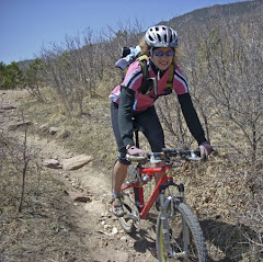
We had another fantastic family day on Friday.  Of course, Friday evening was the end of the amazingly long culmination of the aforementioned Green Gable-athon.  Hallelujah!  Saturday morning we visited for a bit with the family before they were on the road for Oregon.  It was a great visit and the little girls cried because they did not want to leave their favorite Auntie - aaah!  After they peeled out of town, we were torn as to what we wanted to do for a workout.  While we ran short both Thursday and Friday, for some reason we were not overly motivated to run.  What ...?  Add to that the fact that Kathleen has been chomping at the bit to get out on the bike  - she feels a bit boxed-in when she does not have her OPTIONS!!!  So we drug out the road bikes, shimmed one of her one shoes (chiropractor's suggestion), and headed out for a ride.
 South Suburban Reservoirs - Stratton Open Space
 Happy "Wheels"?  Enjoying the view of downtown Colorado Springs
Bundled up for a ride!

We were able to get in a nice bike ride, although it was a bit brisk at times, especially the 4.5 mile descent off of Gold Camp Road - in the shady side of the mountain, BRRRR!  We posed for a pic at the top of Gold Camp while warming in the sun for the cold drop back to Highway 24.  On the way down, we saw a gal coming up the road on roller skis.  Kathleen has always been intrigued by the roller skis and I could see the wheels turning in her head.  Oh. No.  We rode 30 miles and were ready to be inside the warm house when finished - those wind chills are a bit stout on the bike!
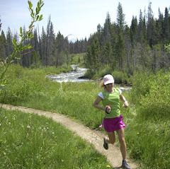
Sunday we wanted to try out fresh turf for a run.  We picked one of the staples of the Incline Club running routes - Ute Pass Trail to Waldo Canyon and back.  It is close to home and is a lollipop loop that starts at the Cog Railway Depot in Manitou Springs.  The Ute Pass Trail is part of the Ring The Peak Trail network that is being mapped around the perimeter of Pikes Peak.
 Getting started
 Starting up the Ute Pass Trail - lots of climbing to come!
 Original intersection of the Ute Trail and Ute Wagon Trail

The Ute Pass Trail is actually an abandoned road bed that was part of the original Ute Trail used by Ute Indians to travel in to Manitou Springs from Eastern Utah.  The Utes believed that the gods lived underneath Manitou Springs, and that the bubbling in the spring waters was the breath of the gods coming to the surface. 


 Heading up Waldo Canyon

After the long climb on UPT, we dropped down the connector to Highway 24, crossing over the road to the Waldo Canyon trailhead.  From there, it is back on the climb - theme for the day!  While it was completely sunny and blue sky when we started, weather was pushing in so we had to be diligent with our pacing and not lollygag which we are prone to do!!!  Waldo Canyon is a lollipop loop - 2 miles out, 3.5 mile loop around the canyon, and then the 2 back out.  High point for the run was at the top of the loop ~ 8130 feet.


 Running along and then this view opens up - Nice! 
 More Climbing....
  Kathleen enjoys the sun
 Overlook from Waldo to the highway
Heading down from Waldo

We had a great time on Waldo.  After dropping down the last section, it was back across Hwy 24 and then up more hills on UPT before the final descent into Manitou.  If we become serious about mountain running, this route will become a staple of ours as well.  Mostly runnable, with a few hiking spots thrown in for good measure.  The route was a bit over thirteen miles with 3700' accumulated elevation gain.  It was a great fresh route and will be on our favorite list before long!!  Elevation profile is below.  Quite a week - we are tired.  Happy Trails!!!

Sunday, June 6, 2010

Ridin' and Runnin'

 Saturday Bike Ride
Saturday morning I (Steve) saddled up the road bike early (to beat the heat AND traffic) and headed out for a nice ride.  I had in mind to head down through the front side of Garden of the Gods over to Gold Camp Road and ride to the end of the pavement.  From there, I would just see what the legs were up for.
Hopped on the bike path below 30th Street

The plan was to get Gold Camp out of the way and get back across Highway 24 before lunatic weekend traffic started to head up Ute Pass.  The red cement along the bike route was already radiating warmth by 8 am - good thing I started early!
Safely across Highway 24, climbing 26th street

On my right in the photo above is Red Rock Canyon, where we frequently trail run.  A couple observations from the bike:  1.  You can coast on a bike, you can't on a run.  2.  On steep hills, you can walk on a run, you must keep pedaling on a bike or you will fall over.  3.  It is pretty exhilarating to cover your first 6.5 miles in 18 minutes - wishful thinking on a run for me!!  4.  Stuff comes at you really, really fast at 36 mph compared to 7 mph.
South Suburban Reservoir and the Broadmoor Hotel
My trusty Steed, High Drive in the background

Photo above is above the Gold Camp / High Drive intersection, High Drive being the dirt road heading up canyon in the center.  This is where you come out of Bear Creek Park and start the steep climb up High Drive to the turn around during the Summer Roundup Trail Race.  Rode to the end of the pavement and turned around to haul back down Gold Camp.  Overall, from crossing Highway 24, 26th/Gold Camp is a gradual 4.5 mile climb and makes a great workout for finding a good climbing rhythm on the bike.  This section is a weekend hotspot for road cyclists and triathletes doing repeats, and yesterday was no exception.  I saw only one car (other than parked cars) but probably 40 bikes.
Back in the Garden

As suspected, Hwy 24 was rocking when I got to cross back over.  I don't mix well with 55 mph traffic!  Headed up through Pleasant Valley and back into Garden of the Gods.  Not to disappoint the trail faithful, I rode the dirt trail from the end of 31st Street all the way up to Gateway Road.  I decided to hop in and ride at least the Juniper Way loop around before making my way home. 
Back side of the Garden
Pikes Peak from the visitor's kiosk on Ridge Road


The prominent scar on the hillside below the peak is the Incline, just FYI.  I was feeling content with the volume of the ride, so just did the front loop, headed back over Flying W and made my way home.  It was a good ride, although I am itching to be back to full-time running.  But I will gladly do both as opposed to being sidelined.  30 miles on the day and feeling strong. 

Stats:  30 miles, 2500' elevation gain
Shoes - Sidi Dominator

And now some running...
View from the truck, entering US Air Force Academy

Got over to the Academy right at 8 when visitors can enter and headed for the Falcon Trail.  Forecast was for another warm day, so I wanted to start early.  We may have to check out our alternate entry point off of Blodgett to access the trail so we can get rolling earlier in the summer!
Above the BX, with a look at Pikeview Quarry

The clouds moved in early to the south, making the decision to run at the Academy even better.  Pikeview Quarry, which is on the hillside above where we live, was used quite a bit in the building that took place at the US Air Force Academy and many other building projects in the Pikes Peak region.  Not much going on there now, though, as landslides have dropped nearly 2 million tons of limestone from the face of the mine, halting reclamation efforts.  Read about it here if that sort of thing interests you.
Awesome view of Blodgett Peak
A little trail video.
From the top of the climb, looking to the water treatment plant

The legs felt really heavy by the time I hit the big climb on the back side.  As noted in the video clip, it was humid and the ridge I was climbing had effectively blocked the breeze.  I decided to stay conservative on the climb and see what I had in the tank at the summit, which is basically halfway through the run.  In the center of the photo above is the saddle from the base of Blodgett that will be our impromptu entry point to the Falcon Trail loop.  It appears to be about a 2 mile spur from the ridge, down through the horse trails to the Falcon Trail.  That would make a nice 17-ish miler, with a grunt out to the trailhead at the finish.
Hit the picnic area, feeling pretty good

I recovered nicely after the climb, got my breeze back, and even had about a 1 minute cloud pass over - just enough for a brief refreshment.  I started to get a little roll in the legs and then realized I had summited only a minute and change slower than my best ever time at Falcon.  Hmmm ... maybe I should push it a bit?
Final climb of the day, overlooking the Golf Course

I pushed pretty good rolling out toward the finish of the loop.  My legs probably felt as good as they did leading up to Greenland, so I was encouraged by this development.  I finished the 13 miles just 25 seconds over my best time from last year.  Given the events of the last few weeks, I will take that.  I am also glad to see the cycling has at least helped me maintain my fitness level.  It was a good day on the trails.  

Shoes - LaSportiva Wildcat

By the way, if you want to read about some really hardcore mountain running in our back yard, have a look at Tony Krupicka's latest blog entry - some of those trails are on the HT To-Do List, as soon as we have the legs for them!!!

Monday, May 25, 2009

Some NEW Stash

So for quite some time, we have been scoping out some trails higher up the Gold Camp/Cheyenne Canon area to add to our running repertoire and we started exploring today. Believe it or not, some of this area has only recently come out from the snow and from what we hear, up on top of Jones Park and Frosty Park, there is still some snow running to be had. I'll pass on that...
So the plan was to drive up Gold Camp Road to the Cap'n Jacks trailhead and start our run with a mellow climb on Gold Camp to the Buckhorn trail. Gold Camp Road is part of the old mining corridor from Cripple Creek to Colorado Springs. There are several tunnels on Gold Camp and we would be using two of them to complete our route today. Tunnel #1, with two cyclists coming through, was just a few hundred feet from the trailhead.
Standing at the top of Cheyenne Canon right past the first tunnel. Our run started a bit over 7200' elevation, so it was a fair amount higher than many of our frequent routes. If you run the Columbine trail up from the Cheyenne Canon visitor's center, you can pop out here after already climbing 1200' - we skipped that today.
Coming out of Tunnel #2, we had a bit of sunshine. It was short lived though, as the monsoon pattern rolled in by mid-morning.
Spoon Falls, right above Helen Hunt Falls, has a nice trickle going over it right now.
Hope the legs are loose now - the start of the Buckhorn Trail and the climbing begins in earnest. From here there is a push of over 800' vertical in a bit over a mile - get the lactic acid moving through those muscles!!!
Kathleen takes a deep breath as she gets ready for the climb.
After the Buckhorn trail tops out, there are a bunch of rolling hills and quite a few whoop-de-doo sections from the mountain bikes and motorcycles - forgot to mention these are full multi-use trails, so keep the ears peeled for motos!
From the top of Buckhorn, Gold Camp road is seen cutting through the hillside as it continues south and west.
There are fantastic panoramic views from atop these trails - Gold Camp continues to climb into the mountains far off in the distance as Kathleen prepares for the roller coaster ride off of Buckhorn to the junction with Cap'n Jacks.
Looking down from Cap'n Jacks to one of the tunnels far below.
Steve climbing out one of the last grunts on Cap'n Jacks trail before the descent to the trailhead. This trail is a series of rollers, more down than up, but still has a few steep punches that really drag on the legs. (They are MUCH easier to roll on a mountain bike, or moto if you're so inclined...) There are also some really cool 10 - 15' high bermed chutes that are almost like a decomposed granite bobsled run - lots of fun, especially when we have had the rains we had this week. Usually the granite is somewhat like running on ball bearings marinated in 10w40 but after a rain, the traction is sweet!
Kathleen is flying down the trail headed for the finish. It was a good day for her to test the recovery and it seems to be good so far - Yeah! The Gold Camp - Buckhorn - Cap'n Jacks loop is about 7.5 miles with 2400' vertical gain - a nice hard workout and we already have some ideas to add to the length (and climb!) That was a good, hard run to get the gunk pushed out of Kathleen's lungs.
I went out for an extra, mellower loop after we hit the trailhead in order to extend the mileage a bit. On the way back to the trailhead, I stopped inside the tunnel for a photo - the flash created a weird glow that was kind of cool. I finished up with about 11 miles and 2800' climbing. It was a great run and opened some expansive new area for us to explore - right on! Hope everyone is well - Happy Trails this week!

Shoes - K Montrail Odyssey
S - Asics Gel Trabuco
Related Posts with Thumbnails