The last few summers since we really got into trail running as a full time way of life, we have not spent much time in Winter Park. In the heyday of our mountain biking 'past', we might sometimes be up there once or twice a month during the summer and fall, hitting the trails, enjoying the cool little mountain town, and generally 'Getting out of Dodge' for 2 or 3 days to regain some sanity. The base area of the resort has changed a lot of late - not so much the mom-and-pop type area anymore, but more the commercialized ski resort. With it came a summer shift too, as the mountain area is now a downhill / freeride only bike park - definitely not our gig (used to call those bikers knuckledgraggers, but in deference to this guy, I must now find a more suitable name !!!). We remember fondly (**old fart musing alert**) our days of "earning" the descent off that mountain by climbing the 2500 or 3000 feet elevation it required to reach that sweet singletrack on top.
But that's a rambling rant for another post, it was Independence Day weekend and we were hoping to beat the searing heat on the Front Range and escape the mass of humanity. Score on both counts....Mountain Bike Capital USA (Winter park's summer tagline) - get ready for some trail running!!!
But that's a rambling rant for another post, it was Independence Day weekend and we were hoping to beat the searing heat on the Front Range and escape the mass of humanity. Score on both counts....Mountain Bike Capital USA (Winter park's summer tagline) - get ready for some trail running!!!

Saturday morning, we headed out to some awesome blue skies and low 60's temps - perfect running weather. Parked over by the Rodeo Grounds in Fraser with the intent to do a big run - a large portion of the King of the Rockies Mountain Bike course. The plan was for Kathleen to run part of the route, then swing up to Elk Creek to refill some of my supplies. Might mention here - we have been bone-dry down on the Front Range, but there is water EVERYWHERE up here thanks to the very late Spring. We had to drive through part of the Fraser River overflowing onto the road, which a car would not have made it through, just to get to the trailhead.

We cruised the Givelo Trail over to Northwest Passage, enjoying the new life that is taking shape after the plundering of the mountain pine beetles. Looks different every time we are back but the "different" is starting to grow on us. We reached the CR50 dirt road and Kathleen decided to stay on the low route, bypassing the 3 mile run up the dirt road to the Tipperary trailhead. She headed over to run the equally awesome Creekside - Flume loop on her own while I trekked up to the Tipperary Creek trail.

Made pretty good time up the road, albeit the exposure to the high altitude sun may have started to get after me. Started in to Tipperary feeling a bit sluggish on the first steep ramp. At the first creek crossing, I took off the shoes and socks and waded across about mid calf deep. I don't run well in wet shoes, so this wasn't optional. The first couple big switchbacks beat me down pretty good - 8 - 10% grade but should have run more of it than I did? Maybe I went too hard last weekend...???
So here is a question that someone out there might have some insight into: We have lived at a decent altitude (~ 6800 feet) for 20+ years. However, the first day we are up high - like 9 or 10k and up, I struggle with the altitude (Kathleen doesn't seem to have this problem). It does not matter if it is bike or run, I always have. Occasional light headed, some bouts of general malaise, and early onset fatigue, maybe even a bad bonk. Generally day 2 is Wunderbar, so I don't get it. Any ideas...???


After a couple lengthier-than-desired walking spells, I navigated the second stream crossing with the aid of a fallen tree, and ran the much more tame incline out to Morse Pass - the top of Tipperary and the intersection with the Spruce Creek trail. This route can be climbed either direction, the Tipperary side is 3.5 miles with about 1300' climb, most of which happens in the first 2.75 miles. The Spruce Creek side is slightly over 2.5 miles with 1400' climb, so much steeper, not many switchbacks, lots of long straightaway views, and TONS of bigger, loose rocks. So we, along with 99% of the other traffic, always go UP Tipperary. Running down Spruce is a little tougher than biking it - you can't roll over the loose rocks like on a bike.


Shortly after making my way across Flume and the start of Chainsaw, I hit all fresh cut singletrack and a major re-route of Chainsaw. The forest has been mostly clear cut from the beetles and it was exposed in the direct sunlight. Then I cramped. Just a short one. Couple minutes later, again. What's the deal with this?? The pounding from the 2.5 mile descent on Spruce, combined with the run over 10k feet, started to pool in the legs a bit on this climb, and I started to doubt that my run would continue on to the ski area. I took 2 S-Caps and 2 gels in a 30 minute spell, but still couldn't shake the twinge in the legs. I dropped out of Chainsaw onto Elk Creek road, where Kathleen was waiting to restock me and pulled the plug - 16 miles and nearly 3000' climbing was plenty for the day. She could tell when she saw me crest the hill that I was done. She had been able to enjoy a great day on the trails as well with 12 miles of sweet singletrack! So we sat out in the meadow for a while, soaking in the fantastic day, then headed into Fraser for some Rocky Mountain Roastery java jolt!!! Later that evening, Hernando's "recovery fuel" - the king of pizza in Winter Park ever since we started going up there in '91. If you dig garlic, you must have your pie Simone style - mmmmmmmmmm!!!


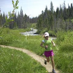
Sunday, we decided to run from the resort side, starting at the base of the ski mountain. It's a little trickier now with most of the trails being downhill travel only, so we had to hop on the steep mountain road and head up. One of our tricks from the bike is to grunt out the shortest route up, then enjoy long meandering trails back down. So we headed up a little over a mile, caught a trail across the forest, and dropped in to what we previously knew as Upper Cherokee, now GreenWorld until you leave resort property. Cruised down through the berms, which is weird for running, and then onto the long stretches of narrow, tree-lined singletrack that is Upper Cherokee. Dropped across the water board road onto Lower Cherokee, which is much steeper and quite technical, and rolled that down to the Ice Hill trail.

Ice Hill is one of those little gut punchers - there are two short ramps with 20+% grades that really suck the wind out of you. It was interesting because we passed through here twice on Sunday. After some strong wind Sunday afternoon, when we ran through again on Monday, there were two fresh tree-falls across the trail - glad we missed out on that. We continued out onto Little Vasquez, an old logging trail that is steep at times and very rocky. It was great climbing along listening to Vasquez Creek and the many raging tributaries through the woods here. We also passed under one of the Denver Water Board viaducts that carry water through the Moffat Water Tunnel right next to the train tunnel.

around the traditional stream crossing unfortunately
After running the service road over to the top of Blue Sky trail, we dropped in there for a nice cruise through the forest with the refreshing sounds of the creek roaring far below us at the top, then crossing over it on the foot bridge (seen above) where the water is practically lapping your feet from underneath the bridge it is so high! Out the bottom of Blue Sky and across the road put us back on Ice Hill, which we took over to Serenity Trail - as the name implies this is a fantastic, peaceful forest run with a nice bed of soft pine needles making it easy on the feet.


and 6.2 miles through the Continental Divide, and down onto the Front Range
Finished out a great run at the ski area village with 11 miles and around 2000' climbing for the day. We tooled around a bit and headed back to the room to get cleaned up and drive out to Lake Granby and Grand Lake - the headwaters of the Colorado River. We were quite curious about the water level and were happy to see it at the highest point we have observed in over ten years since our mountain drought hit hard in the late 90's. Needless to say, it was a zoo over there and we did not linger or bother trying to walk the boardwalk in Grand Lake - half of Colorado's population looked to be there on Sunday!!!!


Boy, did we ever hit the jackpot on weather for this trip. Monday the 4th it was once again bluebird skies when we headed out for a run. We were a bit tired but decided to roll out from the base, across Serenity trail to Ice Hill, then up Twin Bridges and back the way we came. It is hard to leave when the trails are so great, the weather is nice, and the summers are so short up here - have to maximize that time!!!


The first of the "twin" bridges was our closest connection to the roaring creek. The planks were soaking wet and the rapids were jumping 3 to 4 feet up from the current. So we had to pass on the refreshing mountain stream leg soaking - maybe another day :)

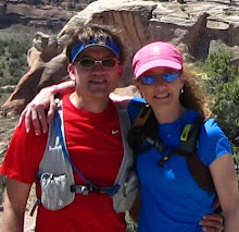
Group mug on Twin Bridges
We rolled back the way we came and cruised in to the ski village on tired but happy legs. 7 Miles to cap off a great weekend getaway. Got some coffee and snacks, and sat out at the base people watching for about an hour before starting the trek back home from the mountains! Sorry it took so long to get this puppy loaded but it has been a crazy week. Happy Trails!!!


21 comments:
fun and beautfil, and fun and beautiful.
yeah, I would say you are "lucky enough"
ahhh....a marmot. I saw one once and had no clue what it was. It's such a mountain thing! The garlic pizza sounds great. Mmm.
Great pictures and a good read again -as always and especially recently living vicariously.
On the Altitude thing - I, and my 12 yr old (after last week in TN running his 10K) find going from here to lower elevation, along w/ more humidity - it's harder to breath when running. Seems like "chewing air", whereas in CO - we breathe it all in.
That sounds like a great weekend.
Hernado's ... mmm, memories of that place and all the dollars ...
There seems to be little in depth research on altitude and the various symptoms folks have. I have certainly heard of the one you mention though. More of just the experiment of one I guess.
Gorgeous pictures. Sounds like things continue to go well for Kathleen. What an enjoyable holiday weekend for sure.
What a fantastic weekend up in WP! I haven't spent much time up there but it looks amazing .. and I'd definitely love to hit the pizza place! Nice job on the runs..you are bouning back nicely, Kathleen!! I am very impressed, and HAPPY!
Please tell Steve that I sometimes have that problem of altitude adjustment, too. I remember having it the first time I ran The Mt. Evans Ascent and I noticed it yesterday when we climbed about 1800' in 2.5 miles. Turned around and going back down was ok. If you get any expert advice on this, let me know!
Hope you're out enjoying this RAINY weekend (are you getting as much crazy rain as us in Denver??)!!
Kathleen,
The skirt and top came from L.L. Bean.I have it in turquoise too. Not quite as expensive as some running skirts.
At least I assume Kathleen wrote that and not Steve!
Dang! Looks awesome and I love the pics of the roaring streams! I'm with Meg... garlic pizza, mmm....
Wow, what an awesome outing. I've been meaning to hit Winter Park area in the summer; I shall plan on it this year. Lots of great pictures of stuff I've wondered about.
I think that hydration is harder to stay on top of at altitude; I would err on the side of "over" in increments to see if that helps. I tend to feel really sluggish in the morning, but that may be the microbrews ;).
I've skied pretty much every Front Range place for several years now, and I can vouch that in spite of the facade at the base, Mary Jane in particular has a very family atmosphere. MJ, Vail and Loveland are probably my favorite areas where it's still primarily about the skiing, rather than being seen in ghetto clown clothes (did I just say that out loud online?)
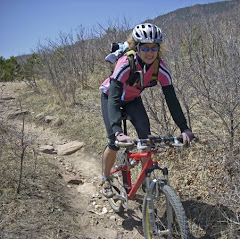
Beautiful river and mountain pics! Cute, colorful running skirt!
I knew I forgot something - the marmot! We saw our first marmot last Thursday in Sequoia - almost posted a pic of it today, too.
Mtrunner2 - you said it, not me :-0 LOL! If you need beta on some runs up there (or rides now that you are Mtbiker2) let us know - we have been on most trails in that valley!!!
As always, super pix. If you weren't a camera nerd, I would not have trail drool all over my keyboard at work! The one "off Morse Pass on the steep Spruce Creek Trail" is screaming out my name--enough to make me pack the car and head there this weekend.
We are still deciding where to go sometime in August for a short vaca. Any sugggestions in northern NM?
Way to get out of town! Dig it. I know what you mean about running in a bike town, though...people think I'm nuts when I say I don't ride. Freak of nature..
As usual, showing us some awesome places to run. Get out of the way crazy cycle-peeps trail runners coming through!
Amazingly beautiful. There is nothing like summer in CO!
The map for the Carter Lake route can be found here: http://www.mapmyride.com/routes/view/41090484
The road is not busy, especially if you go early.
Super stuff as usual. I'm amazed at all the snow. Strange thing about the altitude. I live at 6000ft and sometimes go to 10000. I've never had any problems.
Having done my fair share of hiking and backpacking when I was a young'un, altitude affects each person differently. The biggest difference is that as we increase altitude, our respiratory engine tends to work less efficiently. Lower oxygen pressure in the atmosphere can cause us to slightly hyperventilate, which has the effect of increasing blood pH. Unfortunately, other than spending more time up high, there's not a whole lot you can do about it - except to slow down and enjoy the beauty!
LOVE it. Hilarious that you saw that.
Gorgeous pictures. It just doesnt' get better than that.
Post a Comment