
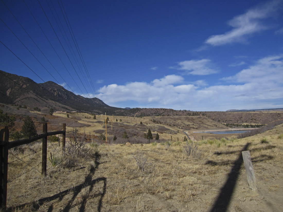
Over the ridge from Blodgett, the USAFA in the distance
Starting from this area, there is about a 2 mile drop in on a variety of dirt roads and horse trails to link up with the Falcon Trail. Given our bizarre winter to date, there were rare patches of snow and almost no mud. It was gray and cool at the start but forecast was for some sun and upper 50's so I was optimistic that the finish would be much warmer.

Finally on Falcon - nice luge trail through the rocks

Nice views along the creek

That cave could be emergency shelter in a storm!

Center of campus - Chapel on the skyline

Circa 1860's - not sure if it is the "original" glass, though!
It was indeed good conditions on the trail. The back side was completely dry and I encountered no ice until dropping out of the Stanley Canyon trailhead to the northeast. Down from there to the road there were a couple sketchy spots that required some mindful attention. With the temperature in the mid 40's, there was just enough of a slimy surface on the ice to make it snot slick. I have been enjoying the consolidated snow traction on the Saucony Peregrine, but it is definitely NOT an ice shoe (not many are...). I traded places quite a few times with guys on bikes - passing on the climbs, getting passed on the descents. it was such a great day to be out and the forecast high winds we have endured lately took the day off. So it was definitely a good day to be out on the bike - a couple guys made mention that they left early to beat the wind but were wishing they would have started an hour later for warmer temps!!
I fatigued noticeably by the time I climbed the ridge above the golf course on the north side of the Academy. This is, after all, January and I have not been maintaining the mileage I did in the fall. I made a conscious effort to ignore the Garmin as I knew at that point I still had 7 or 8 miles to go. Running out the long meadow below the BX, I passed two cyclists that I had traded spots with 4 times. They had laid their bikes in the grass and stood beside the trail with their thumbs out as I went by. I got a good laugh and they shouted encouraging words since they were almost done with their loop! On the trail above the BX, I caught wind of Burger King. Now I am not a fast foodie, but why after almost 15 miles does that smell SO GOOD??? I contemplated the emergency cash stash in my Nathan pack and thought about sauntering in to the BK and getting a Whopper, Animal Style, if you know what that is ;-) Gotta stay clear of the bread, you know??? But alas, with a 2 mile climb out of the Academy staring me in the face, that thought was fleeting...

Exit gate - depart from the Falcon Trail and head UP

Blodgett Peak
The next trail beta I need to work out is a route that starts at Blodgett Peak Open Space and gains access to the horse trails I dropped in on today. That would certainly put this run well over 20 miles and make for a good mid-summer long run bonanza. I am thinking this might involve connecting to the West Monument Creek Trail, which drops in the "V" on the right side of the photo. This gets sticky as Colorado Springs Utilities parked a water treatment plant on the creek and "interrupted" access to the trail. However, there are people who know ways around such things. :)
AFA water treatment facility on the hill to the left,
and one of their reservoirs below right

Can't stand still long - still have to climb out over that ridge

Back over on our side of town - looking over Mt St Francis,
home of The Sisters of Saint Francis of Perpetual Adoration
As you can see, I made it out alive! 17 miles with just under 2600' climb. That was a long run for me at this time of year, however, I enjoyed the test of fitness and found out that I still have a good base. If you are in this area, get out and run the trail - it is not often in January that Falcon is this free of snow and ice. And you never know when they might close access again... Happy Trails
Shoes - Saucony Peregrine


15 comments:
This sounds like a hard run! I love how you run such a variety of places. You have so many places to run and you take full advantage of it. I tend to go out my door and up and down the same old route. It is nice but I should go for more variety -something I do well on my bike - much easier - but not on the run. T has a new route she wants me to try and I will have to go for it.
I hope Kathleen and I feel better SOON. I woke up Fri with the beginnings of a cold. (boo)
I'm glad you passed you test of fitness on the trails.
it's been like spring here, most of the winter. we had a few cold nights, but it's been weird.....
Wow, every CO trail report I've heard this week has been glowing!!! Hoping to check out Roxborough this week - fingers crossed! Great run - hope you didn't get stuck in any wind - it sure is whipping right now!
Just don't run there with more than 3.4 ounces of gels or liquids, and you'll be fine.
Looks fun. Cool view of the Academy, that is a great building.
Trail users are always way ahead of the powers that be when it comes to getting easements and clear rules and signage. Case in point: the Incline. Holy cow. Will it be "official" in my lifetime?
Congratulations on a great run!
You have so many great runs on so many beautiful trails. Hope I see some of these in August. But seeing and meeting you is way more important! I better train!
Nice 17 miler. 2600 feet over 17 miles--is that a tough climb, or an easier day for you? We has a major dust storm Sunday. Fortunately, I was 40 miles north running, and missed the brunt of it, but fought it on the way back home. I was all set to lay the blame your way, but actually, it came from the southwest. :-)
Hope K gets to feeling better soon.
TZ
Very pretty trails, one of my favorites (love the little cabin!). 17 miles is nothing to sneeze at, I'm very impressed!
Feel better, Kathleen!!
Great pix as always. Sorry to hear your runner partner through it all is sick.
you know - you can have a bit of torn paper from a BK bag that once had a Whopper in it from years ago left in your car - and your entire car will still reek of Whopper! I know from personal experience.
Hope you're feeling better, Kathleen!
Yes, you guessed those two trails correctly. I've also been hiking Fox Run (very icy) and tomorrow I'm hoping to head south and try Barr Trail.
That cave in the photo that you indicated could be a good shelter scares me. I always think caves like that make good hiding holes for wildlife! :)
LOL. I told that the emergency cash was for the cab ride home.....
I am considering Falcon for my 14 mile training run this weekend... any thoughts on the condition of the trail now?
Thanks for the reply on my blog (old blog but I get the comments). I think I'll give it a try and let you know how it goes. Training plan says I have to run slower than usual - the ice will help me keep my pace down ;)
Thanks again.
Would you be able to provide somewhat of a map of how you connected blodget open space to falcon? I'd really appreciate it! If you don't want it up here we can arrange something else. Thanks!
Ormes Pikes Peak Atlas has all the trails in the area. There are a variety of connections.
Post a Comment