One thing we ALWAYS do before heading new places is to get the "dirt" on trails. There is a well organized group of races in the Pagosa Springs area that are put on by Morgan Murri under the umbrella of Gecko, which raises funds to help children get reconnected with the outdoors. Morgan was super helpful with emailing us details about the area, giving us some advanced notice on trail conditions, and providing great maps to download on the Gecko website. Timing was unfortunate as we caught him in a busy week between out of town races - we would have liked to get in a run with him. Next time for sure! Read about the children's program, as well as the race series, by clicking on the logo below. Oh, and then sign up for some races while you are at it!
Tuesday Run
Enough trails within that "little" map to run several days out here
Launch point - Fourmile Stock Trail - a mulit-use/ATV trail
Kathleen climbing Fourmile Stock Trail
Finally on the sweet singletrack
One of many sweet trails - we could have posted hundreds of photos,
however, running them was more fun!
Beautiful meadow, but we weren't supposed to see it...
Sweet forest trail - plenty of water over in this area
Notice how tall the blue ski trail posts are - a "little" snow falls over in these parts!
Loamy forest trails emerging from winter's slumber - some wet...
...and some already dry.
Awesome singletrack - mile after mile
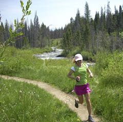
Kathleen cruises through the pines
Think twice about running over these - not as easy as it looks!
Not quite the yoga circle from the Rim Trail in Aspen, but someone spent a little time on this!
Quick Jaunt before heading Home
Early morning over the San Juan River
Overlook on Reservoir Hill
Cool looking benches along the disc golf course
Bye, Bye snow - Wolf Creek Ski Area on the way home
We wanted to hit up the trails that make up the Turkey Track Trail Half
Marathon, so we headed out to the race start in the Turkey Springs
recreation area north of town on Tuesday. We knew that there may be some mud in spots since there had been a decent little snow on Sunday right in the middle of spring drying on the trails. It really was not bad at all given the fact that most of our time was spent between 7600' and 8200' on mostly forested trails.
Kathleen climbing Fourmile Stock Trail
After climbing Fourmile trail, we took a left down a dirt road, watching for the trail to take off to the left that is used in the race. The trails are distinct, but not marked, so paying attention to the the map helps. And the singletrack was worth the wait - pristine and primitive may best describe it. It is refreshing to run narrow trails that are not trampled by 100,000 of your "closest friends" every weekend. Sometimes being far away from the Front Range is NOT such a bad thing!
Nicely thinned and neat forests - they do it right down herehowever, running them was more fun!
Beautiful meadow, but we weren't supposed to see it...
We were blissfully cruising along, clicking off the miles of awesome trails when we arrived at this huge meadow. Unfortunately this was not part of the half marathon course. But when you are digging the trails and enjoying the scenery, sometimes things go unnoticed!
Ignorance is bliss on trails like this!
So on we went, cruising through some neat forest that had recently seen a huge amount of elk traffic, although we saw no elk this day. Having briefly calculated what some of the turn points should be on the course, at a certain point we started to realize we ... were ... lost. Now, on a day when you are feeling great and running unbelievable trails, this is a minor issue. However, when you are keenly aware that any time in the near future your running partner could completely run out of thyroid hormone and crash, "lost" becomes an unnerving event. So I turned on the nifty little "Return to Start" function on the Garmin and compared it to the map. The images didn't jive ... hmmmm? Fortunately, we had a phone conversation with Morgan on the way out to the trails that morning and he had mentioned that the Turkey Springs Road was as far west as we wanted to ever go on the trails. Second fortunate event was that I had printed both the Half and Full maps from the website. We ended up on a road, heading approximately NW according to the GPS. I made a couple out and back trips on some trails and had Kathleen wait at intersections to save some mileage on her legs. Finally off in the distance I could see a T intersection and picked it up a bit. Luckily it was signed "Brockover Road" - part of the Marathon course - woohoo!!!
We were at the intersection with Turkey Springs Road, which we knew
would take us all the way back around to the car. The downside was that
my rough calculation had us at 4+ miles out and well over 13 miles into
the run, already past Kathleen's longest since her RAI treatment, and
her energy was flagging. So I told her to continue at whatever pace was
comfortable and I was going to hammer to the car, then head up the road
and pick her up. So I had an unplanned tempo session and made a courtesy taxi trip to catch her on the road. It turned out to be a great run, with just a little sketchy period thrown in! Given some more time to explore and familiarize with the trails on the marathon map this could become a great place to hang out! Ended up with around 18 miles and 16 miles on the day - a bit more than we were looking for but well worth the extra effort.
Shoes - Saucony Pergerine
Thursday Run
Given the big effort Tuesday, we decided to take a break Wednesday, instead driving over to Durango to do some shopping and snooping around. It was a nice day to have some down time and Durango will require another trip down to this part of the state at some point in the near future. Plenty of trails there too, yet some of their stellar ones require a summer time visit when the winter stash has cleared out. One thing we knew for sure, if Kathleen had legs we would be back out in Turkey Springs on Thursday morning.
The "other side" of Fourmile Stock Trail
Thursday we woke to rain, which at home means "don't worry about a run today". However, away from home it often means "watch for a good window and go for it". So the rain stopped and we took off for the trailhead. Given the sketchy weather scenario and the chance of rain and/or snow, we decided to do some trails very close to Turkey Springs road in case a quick getaway was needed! We noticed on Tuesday that Fourmile continued across the road where we turned as a singletrack, so we took off that way, which is also a cross country ski trail in the winter months and is marked at junctions with the blue posts.
Notice how tall the blue ski trail posts are - a "little" snow falls over in these parts!
Awesome singletrack - mile after mile
About forty minutes in, it started to snow. It was kind of that graupel, or corn snow, and so we headed back just in case. We were about out to the Piedra Stock Trail, west of Turkey Springs Road when we turned around. We thought we would throw our shell jackets on and see what happened. We made it all the way back to Newt Jack Road, which was the turn for the race, and the sun emerged. We ditched the jackets and decided to catch Turkey Springs Rd and loop all the way back around to the west and hop on the Fourmile Stock trail again - it was that good!
This appeared to be some sort of lava-type flow that cut through this meadowKathleen cruises through the pines
We ran most of the remainder of the route just ahead of the next round of the storm. We had about a mile descent to the car on the Fourmile, the same stretch the races finish on. The rain started slowly, then picked up in intensity and we ultimately finished wet but smiling. We eeked out another 13 mile run on excellent trails. Another awesome day!
Shoes - Saucony Peregrine
Quick Jaunt before heading Home
Early morning over the San Juan River
Overlook on Reservoir Hill
Friday morning before heading home, we decided to try out some trails on Reservoir Hill, which is right in town across the highway from where we stayed. The trails are steep to get up on top, then wind their way around the hilltop, eventually dropping back down one of the sides. It is used for Nordic skiing in the winter, but you wouldn't catch me on these trails on skinny skis!!!
Continental Divide overlook, San Juan River below
We made the outer loop of about 3 miles and hopped across the highway to get ready for the trip home. We had some early signs that we may have squeezed everything out of Kathleen's thyroid that we could have - of course, you probably already read earlier in the week that this was indeed the case. But we had a pretty good time burning that little organ up on this trip and we most certainly need a return trip at full steam! While we may not have timing on our side, health-wise, to make it down for Turkey Track races this year, it is now in the proverbial bucket.
Highway 160, heading east to Wolf Creek PassBye, Bye snow - Wolf Creek Ski Area on the way home


10 comments:
What a great trip! I love how adventurous you guys are!
I love that part of the state, though I too have spent too little time down there. When the kids are bigger (that's my mantra).....
Congrats on some great runs, and I'm glad the "getting lost" wasn't serious in the end.
Since I've been on vacation, I'm just getting caught up on blogs and saw that you posted that the worst part of the Graves Disease process should be behind you - this is wonderful! I hope S has a lot of fun at the race and that it isn't too very windy and that K can walk after that very long run! I have to work up to long runs, but I know you're a Superwoman, K!
Glad you figured out quickly how to not make that being lost turn into a disaster. You two are certainly adventurous. I can't imagine what you'll be like once Kathleen is on her way back up big time!
Nice pictures but it is much more gorgeous where you live. I guess that is why you have so many "friends" on the trails.
So glad to see Kathleen out on the trails, and you two enjoying yourselves. There is so much to explore on the western slope- you could run a different trail every day and never run out of new places to run. Wishing Kathleen continued success and more energy every day.
I've never been to Pagosa Springs, but it looks lovely. It reminds me of a trail that I ran near Salida last year. We certainly live in a beautiful state and I would like to do more exploration.
I am happy that Kathleen is doing so well.
Good luck on your race next weekend!
just catching up on your latest (extended) adventures.....this is another one of my big fears of trail running (Im not good with maps - lol) BUT that pic of Hwy 160 heading east to Wolf Creek Pass is calling my name.
Steve - so excited about your race this weekend. I know you are tough and READY. Here's an oldie but goodie to get you pumped up. http://www.youtube.com/watch?v=lEuiqarzWDY&feature=share (Tahoe Rim Trail Endurance Run theme songs)
I should have ended with Good Luck! Have Fun! and Strong Heart, Strong Mind !
Oh man you should get into marketing for the local tourism board there. How awesome is this and all your photos of the great runs! I am green with envy and need so seriously get myself over there. Fantastic!
All the best for the upcoming race Steve! Run strong!
K- I'm not keeping up with the previous month's challenges on a daily basis. These are just short little mini workouts, in addition to my typical daily stuff, but I've found them very beneficial.
Post a Comment